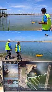
Map Afrique provides hydrographic engineering services with fully-integrated systems for 3D bathymetric surveying, underwater object positioning, offshore construction, underwater archaeology, and wrecked rescue operations. We deliver high-resolution data that consistently meets even the most demanding requirements of marine survey projects. We utilize state-of-the art technologies that ensures high safety, high accuracy, reduce survey time and cost and also improve work efficiency.